
Oil and gas companies and their associated utilities require strategic geospatial solutions to enhance oversight of electrical infrastructure. Integrating geographic information systems (GIS) with power system analysis software enables real-time asset visibility, improves operational safety, and supports data-driven planning. Industry studies and field implementations have demonstrated significant operational benefits, including reduced data retrieval times, improved maintenance efficiency, and enhanced system reliability. This approach supports compliance with NFPA 70E, Standard for Electrical Safety in the Workplace, and IEEE Std. 1584-2018, IEEE Guide for Performing Arc-Flash Hazard Calculations, reduces operational risk, and strengthens capital investment decisions—delivering measurable value across large-scale, geographically distributed field operations.
Electrical networks are fundamental to the reliable operation of oil and gas facilities, and effective management of system components is essential for optimizing efficiency across extraction, processing, and distribution processes. As infrastructure expands and becomes more complex, the demand for advanced information management solutions continues to grow.
Modern GIS-based platforms, when integrated with electrical modeling and analysis tools, provide a comprehensive framework for managing these networks. This integration enhances operational visibility, improves system understanding, and enables more informed technical and economic decision-making. Digital transformation initiatives in asset-intensive industries have been shown to significantly improve operational performance and reduce troubleshooting time.
THE VALUE OF INFORMATION
Over the past decade, operational data management has evolved from paper-based documentation to integrated digital systems. This transformation enables advanced data acquisition, storage, and analytics, improving operational efficiency and insight.
Effective systems must ensure:
- Adequate data availability
- High accuracy and timeliness
- Rapid accessibility
Structured data management supports a comprehensive, digitized inventory of electrical infrastructure, including medium- and low-voltage systems and associated process equipment. In current advanced internet architecture, cybersecurity and real-time information access are essential because data center infrastructure and data science algorithms increasingly govern data integrity, availability, operational insight, and secure decision-making across distributed industrial environments.
OPERATIONAL OPTIMIZATION
An organized and accessible database supports multiple operational functions:
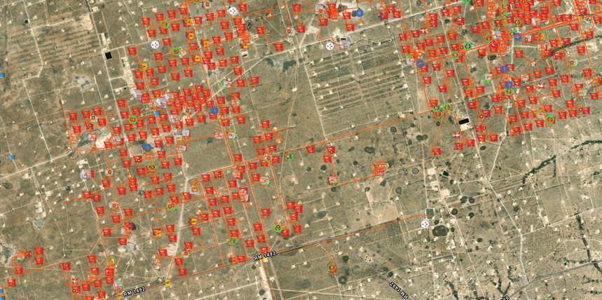
- Electrical system operations. Field-validated models with the individual geographical information of the components enable simulation under normal and contingency conditions, improving reliability and reducing unplanned outages. The geospatial component allows the operators of the electrical system to make decisions regarding the efficiency of the troubleshooting and improve the response times, as the position of the assets is displayed on satellite imagery maps.
- Planning and investment. Accurate asset data, enriched with truthful information captured from the field, improves expansion and upgrade planning by enabling more efficient capital allocation. When the database is comprehensive, precise, and geolocated, planning projects are managed on a reliable basis because the number of assumptions becomes negligible. Asset management is also optimized because the data collection process records each asset’s condition, age, nameplate information, and other relevant details, along with attached photographs that support validation, maintenance prioritization, and long-term investment decisions.
- Equipment and personnel protection. System modeling of electrical components worldwide supports protection coordination because the protective devices are captured with high-resolution pictures, allowing the engineering team to utilize the real type, model, manufacturer, and time-current characteristics for an accurate estimation of fault-clearing times and selective device coordination. In addition, a reliable arc flash analysis in accordance with NFPA 70E and IEEE 1584 improves worker safety.
Figure 1 shows how the previous functions interact to provide the final user with fast, straightforward, and effective access to a comprehensive overview of their entire electrical infrastructure.

IMPLEMENTATION METHODOLOGY
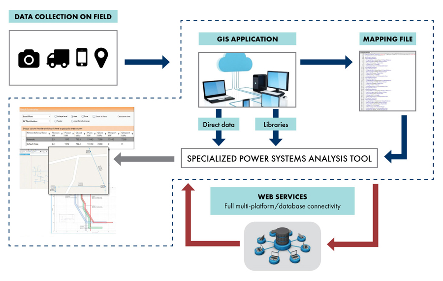
A typical implementation of electrical system inventory and geo-modeling for engineering analysis and asset management includes a structured sequence of activities intended to transform dispersed field information into a verified, geolocated, and analytically useful database:
- Geographical engineering database design. Customized attributes, standardized equipment forms, hierarchical asset relationships, and display icons are defined for each electrical component to collect information under a consistent technical structure.
- Field data acquisition, validation, and mobile data collection. Qualified technicians conduct site visits using mobile applications to record attributes defined in the database design, including location, nameplate data, equipment condition, age, installation characteristics, and photographic evidence to support subsequent engineering review.
- Data processing and standardization. The information collected in the field is synchronized to a controlled cloud environment, where completeness checks, spatial verification, and technical quality control can be performed before the records are accepted as part of the authoritative asset inventory. Engineering personnel review the collected information, standardize naming conventions, resolve inconsistencies, and provide feedback to field crews, thereby refining the collection process and improving the reliability of the final database.
- Integration with analysis software. The validated geospatial database is migrated or linked to a compatible power systems calculation engine, allowing the same asset records to support load-flow, short-circuit, protection coordination, arc flash, harmonics, reliability, motor-starting, and network optimization studies. This is developed from a consistent data foundation, reducing duplicated effort and improving the traceability of assumptions, calculations, and recommendations.
An illustration of the process is displayed in Figure 2.
INDUSTRY APPLICATION
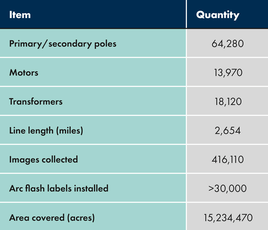
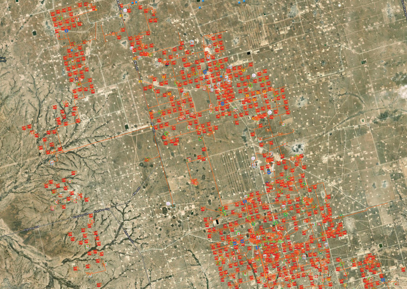
Considering that a geographical database can be extended to more than 2,000 gigabytes, the described methodology can cover data ranging from small individual facilities to complex, widespread sets of oil and gas fields. A real case within the Texas industry demonstrates the scalability of the asset management optimization techniques and digitalization for managing complex electrical systems in geographically dispersed operations. Using the number of devices of multiple geographical databases and safety compliance summarized in Table 1, Figure 3 shows the extent of a sample section of the mentioned application.
OPERATIONAL BENEFITS
A structured asset mapping and management approach, along with digital data availability, provides the following operational advantages:
- Geospatial visualization of assets for accurate decisions considering the field’s real constraints
- Detailed equipment data recording, which allows the user to verify the condition of the equipment
- Centralized GIS database accessible for every stakeholder
- Integration with electrical analysis tools, providing a multi-analysis option
- Asset classification and reporting, which appropriately creates and tracks its lifecycle
- Arc flash labeling for a safe workplace and regulatory compliance (OSHA/NFPA 70E/IEEE 1584)
- One-line diagrams with simulation results that support the engineering analysis
Collectively, these benefits demonstrate how integrated geospatial asset management improves visibility, data accessibility, analytical consistency, safety compliance, and operational efficiency across electrical infrastructure.
The exposed methodology remains compatible with cybersecurity policies because the final user can determine whether the database is allocated within its own protected servers or hosted in the cloud GIS platform, according to internal governance, access control, and information security requirements.
Artificial intelligence further amplifies these benefits by converting complete electrical equipment inventory, associated photographs, cloud-accessible records, and geographical stamps into actionable intelligence. Machine learning and computer vision can support anomaly detection, automated data validation, predictive maintenance prioritization, and contextual decision-making, thereby increasing reliability, traceability, and operational value across widespread distributed assets.
CONCLUSION
Integrating geographically based asset management with electrical power system modeling provides a rigorous framework for managing any kind of industry, as shown for the oil and gas electrical infrastructure. By combining geolocated field data, validated equipment information, and analytical simulation capabilities, this approach enhances safety, reliability, planning accuracy, and operational efficiency, while supporting informed capital investment decisions and long-term asset optimization across geographically dispersed facilities.
REFERENCES
- ESRI. Modernizing Asset Management-Electric and Gas Utilities. eBook. www.esri.com/content/dam/esrisites/en-us/media/ebooks/electric-asset-management-ebook.pdf.
- Buck, C., Clarke, J., et al. “Digital transformation in asset-intensive organizations: The light and the dark side, Journal of Innovation & Knowledge 8 (2023): DOI:10.1016/j.jik.2023.100335.
- Deloitte. “Digital transformation in oil and gas companies,” blog, www.deloitte.com/us/en/services/consulting/articles/digital-transformation-in-oil-and-gas.html.
- EPRI. Condition-Based Maintenance Guideline: Including Startup and Shutdown Monitoring. 2022. www.epri.com/research/products/000000003002023778.
- NFPA 70E, Standard for Electrical Safety in the Workplace, 2024 Edition.
- IEEE Std. 1584-2018, IEEE Guide for Performing Arc-Flash Hazard Calculations.
- IEEE Std. 3007.2-2010, IEEE Recommended Practice for the Maintenance of Industrial and Commercial Power Systems.

Brad Fryrear is an NFPA Certified Electrical Safety Compliance Professional for GERS, specializing in arc flash risk assessments, power system studies, and utility asset management. His work focuses on leveraging modern technologies, including GIS, to improve the accuracy, efficiency, and accessibility of electrical system data. He received his BAS from the University of Texas Permian Basin.

Fabio Perea is a NETA Level 3 Certified Technician, an NFPA Certified Electrical Safety Compliance Professional, and a Senior Electrical Engineer at GERS. He works as a power systems consultant specializing in large-scale transmission and distribution planning, geographical information system interfaces, protection coordination, optimization techniques, and arc flash safety studies across the oil and gas, mining, and utility sectors. He received his BS in electrical engineering and a post-graduate degree in transmission and distribution of electrical systems from the University of Valle in Cali, Colombia.